As a result of the Great Migration, by 1640 the estimated population of New England rose spectacularly from fewer than 500 colonists to more than 26,000. Within three years (1628-1630), the English colonial entity known as Massachusetts went from a tiny settlement of ex-Cape Ann and ex-Plymouth people on Beverly Harbor to a huge “province” embracing all existing and future settlements of Cape Cod, Plymouth, Boston, Cape Ann, and Maine.
Charles I’s royal charter was designed to put to rest all other conflicting claims to the region, including the 1623 Sheffield Patent held by New Plymouth. Edward Winslow and Robert Cushman of Plymouth had purchased a patent from Lord Sheffield for lands including Cape Ann, as the wording of the Sheffield charter makes plain [1]:
Wynesseth that the said Lord Sheffield…Hath Gyven…for the said Robert and Edward and their associates…a certaine Tracte of Ground in New England in a knowne place there commonly called Cape Anne…Together with the free use of the Bay of Cape Anne…and free liberty to ffish, fowle, etc. and to trade in the lands thereabout, and in all other places in New England aforesaid whereof the said Lord Sheffield is or hath byn possessed…Together also with ffive hundred Acres of free Land adioyning to the said Bay…for the building of a Towne, Scholes, Churches, Hospitals, etc. also Thirty Acres of Land and besides…to be allotted…for every particular person that shall come and dwell at the aforesaid Cape Anne within Seaven yeares next after the Date hereof.
The Council for New England thus had assigned Cape Ann to Lord Sheffield, which he sold to Plymouth Colony. The sale was unauthorized by the crown, however, and therefore unenforceable, which is why William Bradford refers to the patent as “useless”. On the basis of it, however, in 1624 the Plymouth Company in England sent the Charity on a fishing expedition to “Cape Anne”, stopping at New Plymouth to pick up a salter to erect a saltworks, a ship’s carpenter, and some planters to help build a stage at Gloucester Harbor and trade with the Indians there. According to Babson’s retelling of Bradford’s account [2]:
The master—one Baker—was a “drunken beast;” most of his men were like their master; and a poor voyage was the natural result. “Mr. William Peirce was to oversee the business, and to be their master on ye ship home [the Anne]; yet he could do no good amongst them, so as ye loss was great.” Some gain, however, was derived from trading with the Indians for skins.
The venture failed, leaving Plymouth Colony only with a seasonal fishing station at Straitsmouth (in present-day Rockport) at the same time as the Dorchester Company was at Fishermen’s Field. In its rush to get colonies going in New England–in competition with the more prosperous Virginia Colony of the London Company–and learning that Sheffield was selling his charter to Pilgrims in Plymouth, the Council for New England had awarded Rev. John White a charter to establish a Puritan fishing colony on Cape Ann. Thus, real grounds existed for conflicting claims to Cape Ann, which may explain the historian John Wingate Thornton’s interpretation in The Landing at Cape Anne (1854). Thornton, who notes there were as many as 22 independent charters to overlapping claims in New England, essentially attributes the first failed founding of Cape Ann to fishermen of the Plymouth Colony acting under the Sheffield Charter as early as 1623 [3].
In addition to the conflicting claims between the Dorchester Company and Plymouth Colony, there was Ferdinando Gorges’ and John Mason’s earlier king’s grant (from James I), which had included all of eastern North America north of the Virginia Colony, a deal that predated even the founding of Plymouth, at a time when New England appeared on many maps as “Northern Virginia”. The king’s grant boundaries were later reduced to all the land between the Merrimack and the Kennebec, which Gorges and Mason later divided between them, essentially founding New Hampshire and Maine. Maine, however, was part of Massachusetts at the time. Gorges’ and Mason’s interests in Cape Ann were pursued unsuccessfully in court in England by Gorges’ son Robert (after the failure of his Wessagusset colony) and by Mason’s heirs in the Massachusetts General Court a full 50 years after the fact [4].
So, Dorchester Company assets (mainly barrels and salt) abandoned on Cape Ann in 1626, when Conant et al. relocated to Salem Village, passed in brief succession to:
- Fishermen from Plymouth Colony—based on the Sheffield Patent;
- The New England Company for a Plantation in Massachusetts Bay—based on the Council of New England patent engineered by Rev. John White from the ashes of the Dorchester Company; and
- The General Court of the Massachusetts Bay Colony, which accessioned Cape Ann in a royal charter from Charles I that abrogated all other claims.
This succession was the basis of conflicts among the stakeholders in Cape Ann and helps explain the famous confrontation in 1626 between a Mr. John Hewes and Captain Myles Standish, both of Plymouth. Hewes (Hughes) was representing West Country merchants—including some old Dorchester Company investors who had lost money and hoped to take advantage of the situation on Cape Ann to recover their losses, a situation they may have learned about from John Lyford, who had briefly returned to England. Essentially, Hewes sought to commandeer the abandoned Dorchester Company fish pier and stage, along with the barrels and salt [5].
Captain William Peirce, master of the Anne for the Plymouth Company, fishing Cape Ann waters after offloading more Pilgrims at Plymouth, was anchored in Gloucester Harbor at the time. Peirce sent word to William Bradford at Plymouth about Hewes’ imminent takeover, and Bradford sent Myles Standish to protect Plymouth’s interests. Standish, known for his truculence, came prepared for a fight. Bradford was anxious to reclaim the fishing station at Fishermen’s Field. In his commonplace book and in letters beseeching authorities to clarify Cape Ann’s legal status, he complains that Plymouth has been “dispossessed of Cape Ann by adventurers” [6].
The conflict between Hewes and Standish occurred in 1626, not in 1623 as implied in the commemorative sign in Stage Fort Park. The conflict was mitigated, and bloodshed avoided, through the intercession of Roger Conant (representing the Dorchester and New England Company investors). Conant had not yet left for Naumkeag, because Bradford’s account refers to Conant and his men “rushing from their huts” (i.e., wigwams) to prevent bloodshed after Hewes and his men barricaded themselves behind hogsheads on the pier and Standish threatened to open fire on them.
Commemorative Sign in Stage Fort Park
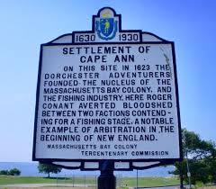 In this great, locally mythic, stand-off in Fishermen’s Field, Conant calmly explains that the pier and stage are property still belonging to West Country investors he represents, and Captain Peirce proposes that his crew help Hewes build a new state-of-the-art fish pier and stage for Plymouth’s use somewhere else. Perhaps this could be done at Gap Cove in Straitsmouth, where Plymouth men already operated a seasonal fishery. The specific outcome of the conflict was not recorded, but Conant and company subsequently left the area for Naumkeag, Standish was recalled to Plymouth with Peirce, and Hewes and his Plymouth men left, not for Straitsmouth, but for a trading post on the Kennebec River in Maine.
Plymouth gave up its interest in Cape Ann at that point and focused on successfully establishing a fur trading post and fishing station on the Kennebec River. Isaac Allerton of Plymouth conveyed a Council for New England grant of land for the Kennebec colony, which was officially sanctioned in January 1628/29, to be overseen by Edward Winslow. This settlement was called Cushnoc, in a region the Abenaki called Wawenock [7].
Of several mostly copied accounts of the confrontation at Fishermen’s Field, I found none that tells us if a new pier was ever built or if the old one was put to use again and by whom—but all seem to laud the Conant-Standish-Hewes stand-down as a testament to sound leadership and righteous conflict resolution in the colonies. Everyone undoubtedly used the fishing station, as Gloucester Harbor remained an active site of seasonal land and sea fishing operations. Some fishing families were permanent residents on Cape Ann as squatters in the 1630s, chiefly in Annisquam and Magnolia, but a permanent plantation was not officially ordained in Gloucester until 1639 by decree of the General Court [8].
It has been suggested that Conant leaving Cape Ann for Naumkeag was a direct consequence of the Hewes-Standish conflict. There is no evidence for this, however. Primary source accounts suggest that Conant’s decision to leave preceded both this conflict and John’s White’s entreaty to keep the enterprise alive. According to summaries given by Hubbard and White, Conant felt that the weather was too harsh, the land too poor for farming, the best fishing grounds too far away, the native-style housing too poor, and the prospects of establishing a model fishing station unlikely. Prior to agreeing to White’s entreaty, Conant also may have thought of establishing a settlement of his own as an entrepreneur, focusing on the Indian fur trade, as he had done at Nantasket. In 1631, Conant did leave Salem to form a trading company with Peter Palfrey and others “for traffic in furs, with a truck house at the eastward” (i.e., in Maine) [9].
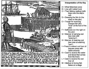
Woodcut of a Model Fishing Station of the 1620s
Early historical interpretations of Conant’s replacement by Endicott in Beverly (Salem Village) seem to reflect masculine concerns about rank or dominance hierarchies. More than one historian, echoed to the present day, assures us that Conant must have felt disappointed to have been forced to relinquish leadership in just under two years and miffed to have had to give up his house for Endicott’s living quarters. However, there is no hint of aggrievement in Conant’s writings, interviews of him, or other first-hand accounts. As a 17th-century “middle class” tradesman, Conant would have had no illusions about being “a person of blood” born to lead. He was an ordinary man with great strength of character who started out as an apprentice salter, became a fisherman, and rose to the occasion. He needed no consolation but went on to serve as a selectman and juror during Endicott’s tenure before resuming the fur trade. He had others’ esteem: Stage Fort for a time was named Fort Conant, for example, and his trading post in Boston Harbor was called Conant Island (now Governor’s Island). Perhaps Endicott resented being superceded within a year by John Winthrop, but that, too, is unlikely. Endicott was Governor of Massachusetts Bay Colony four more times during his lifetime, swapping places with other leaders to meet the charter’s term-of-office restriction [10].
Conant strikes me as a person much like Passaconaway. The Pennacook sachem also was a relatively obscure man with great strength of character who started out humbly—as an entertainer (juggler and magician)—became a shaman, and rose to the challenge of leadership in another conflict situation at around the same time—as the leader of the Pennacook Confederacy. Passaconaway’s influence on peaceful conflict resolution during the Contact Period came at a critical time in Native American history, just as Conant’s peacemaking influence on the settling of Cape Ann and Naumkeag came at a critical time in the history of Massachusetts [11].
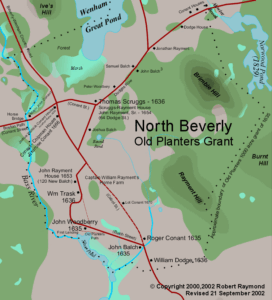
In any case, upon taking office, Endicott did more than appropriate Conant’s house. In the name of the Massachusetts patentees, he appropriated the Old Planters’ lands not in use and redistributed them to the new settlers—creating much bad blood between oldcomers and newcomers, echoes of which may survive provincially to this day. The General Court had ordered Endicott to allow the Old Planters, now technically squatters, to keep only any of their land that they had previously “manured”, their term for putting land under cultivation. In his “Planter’s Plea”, White vigorously campaigns for the Old Planters’ rights. After his intercession, the General Court in 1635 gave a 1,000-acre grant of prime real estate to be distributed among the original settlers of Salem Village [12].
Endicott Land Grants of 1635 to the Old Planters
In 1630, Massachusetts declared all previous grants, patents and charters, such as Sheffield’s, Gorges’, and Mason’s, null and void. The General Court defined the boundaries of plantations, regulated lot sizes, established local committees to allocate lots, and insisted that Native Americans be paid for their land. The Court also regulated trade with the Indians, fixed prices, and required that anyone seeking to purchase land from the Indians first obtain the Court’s permission. Payment for land usually was in wampum—legal tender for everyone in the English colonies until the 1660s—and in kind, especially Indian corn, iron kettles, steel knives, and woolen cloth. Most significantly, in 1639 the General Court declared null and void all land purchases made previously directly with the Indians without the Court’s permission [13].
These sweeping acts made the original settlers of Cape Ann and other places squatters with invalid claims to their properties. They soon flooded the Court with questions about the legality of their deeds and requests for clarification on the status of their property. Some squatters surrendered their land to the newly chartered plantations and townships, whose proprietors sought incorporation to better petition the General Court for permission to re-buy their lands from the Indians under the new rules. The most ancient records of deeds on microfilm in the Massachusetts Archives are heavily redacted, and I speculate that the transactions were selectively blacked out after the fact because they recorded Indian deals obtained outside the aegis of the General Court and therefore illegally. Ultimately, all the townships in Essex County had to repurchase their lands from the grandchildren of the sachems and sagamores who had signed the original deeds, some of which do survive. Masconomet’s 1637 and 1638 deeds to John Winthrop Jr., in the Southern Essex County Registry of Deeds in Salem, for example, are for lands that his grandsons Samuel English, and others, redeeded to Ipswich, Gloucester, and other Agawam towns in 1700/01 [14].
History makes clear how the Indians lost their land to the English, but the story of how the first English also lost their land is less well known. The case of William Jeffreys (Jeffries) is an instructive example of how the new Puritan government of the Massachusetts Bay Colony disenfranchised and marginalized the first English who had settled New England before them [15].
- 1623 With Robert Gorges, Jeffreys explores Ferdinando Gorges’ grant from James I and helps establish a 2nd colony after the failure of Wollaston: Wessagusset, later renamed Weymouth. He buys land there from the Indians.
- 1624 Wessagusset is abandoned after Wampanoag attack. Most return to England. The rest, including Jeffreys, shelter in Plymouth Colony.
- 1626 Jeffreys goes to Plymouth’s fishing outpost at Nantasket, then to Cape Ann with Roger Conant, and from there to Beverly with the Dorchester Company. He sees Magnolia and Manchester en route to Naumkeag.
- 1627-1629 Returning up the coast from Salem Village, he buys Jeffrey’s Creek (Manchester-by-the-Sea) from the Indians, but stays only briefly. In Ipswich he buys Jeffrey’s Neck (Great Neck) and the Jeffrey’s Ledge fishing grounds from the Indians.
- 1630 Governor Winthrop and the General Court void all previous patents and charters, including Sheffield’s, Mason’s, and Gorges’. Plymouth Colony is folded into the Mass. Bay Colony.
- 1631 The Court redistributes land in Magnolia and Coolidge Point, part of Jeffrey’s Creek, to John Kettle, by eminent domain. Jeffreys writes letters of outrage to the General Court. In response he is admitted as a freeman and granted a patent for land on the frontier in Agamenticus (York, Maine).
- 1632 Jeffreys sells the land he bought earlier from the Indians in Weymouth and moves to York. He goes into business with the trader Samuel Maverick and helps build the first house in Hampton (NH).
- 1633 The Court appropriates Old Planters’ land in Salem Village and Indian land in Agawam, including Jeffrey’s Neck and Jeffrey’s Ledge, and awards them to John Winthrop Jr. and others in Charlestown. Jeffreys’ letters of protest earn him a reprimand from the Winthrop government.
- 1634 John Winthrop Jr. and 11 men from Charlestown arrive in Agawam to evict squatters and establish the Ipswich colony as a buffer zone against the French.
- 1635 In response to widespread discontent and White’s “Planter’s Plea”, the Mass. Bay Colony grants 1,000 acres of land to the Old Planters at Salem Village.
- 1636 The Mass. Bay Colony grants 350 acres of land to Old Planters at Jeffreys Creek.
- 1638 William Allen receives a grant of land at Jeffrey’s Creek. Masconomet sells Agawam to John Winthrop Jr. for the establishment of the Town of Ipswich.
- 1639 The General Court declares that all past and future purchases of land directly from the Indians without permission of the Court are invalid (and that Englishmen may no longer live in wigwams).
- 1640 William Allen moves to Jeffrey’s Creek from Salem and builds the first frame house there.
- 1641 Jeffreys, Maverick, and their partners receive divisions of land in York, renamed Bristol.
- 1642 Jeffrey’s first daughter is born in Bristol, Maine, to his wife Mary.
- 1645 Jeffrey’s Creek proprietors request the town be renamed Manchester, which is granted. Jeffreys protests unsuccessfully in General Court.
- 1648 Jeffreys sells his land in Maine, buys land at Newport, and leaves Mass. Bay Colony in disgust to join the Rhode Island Colony instead.
- 1660 Jeffreys sues the Mass. Bay Colony over the loss of his land in Ipswich but is told his purchase from the Indians had been illegal. The Court grants him 500 acres on the frontier somewhere in compensation, which he promptly sells.
- 1675 Jeffreys dies in Newport, Rhode Island, at age 84.
Some first comers remained on Cape Ann or returned there from Salem during the 1630s, even as Puritan homesteaders trickled in from the Great Migration. As nonconformists, freethinkers (and freewheelers), many Dorchester-Company-cum-Naumkeag-Colony people chafed under Puritan hardliners in Salem as much as they had chafed under the Pilgrim regime in Plymouth. The Puritans required mandatory church attendance, for example, and exacted fines for fishing on the Sabbath. For some, such as Abraham Robinson formerly of Plymouth, the frontier-like remoteness of Cape Ann’s coves on Ipswich Bay must have been an attraction [16].
Wherever they were, the oldcomers likely did not appreciate the loss of status and privilege that the massive influxes of newcomers brought. Newcomers to Cape Ann were different—not from Dorset and Devon but from “western” and “northern” counties, such as Wales, Gravesend in Kent County, Ipswich, Norfolk, Surry, and Bristol in Gloucestershire. They had different ways and ideas—sometimes dangerous ideas—such as the heretical notions held by Anabaptists and Quakers, and they had different occupations. Weavers and wool workers flocked to Ipswich and Rowley, and fishermen to the outposts in Casco Bay and elsewhere on the Gulf of Maine, but those coming to Cape Ann after 1639 were mostly farmers, who turned their backs to the sea. Recurrences of conflicts stemming from these economic and religious differences marked the early history of Gloucester, and the argument can be made that those differences and conflicts persisted into the next century and possibly beyond [17].
In addition, newcomers did not especially appreciate the Native Americans, who made unaccustomed demands on their resources. In contrast, the oldcomers on Cape Ann and in Naumkeag were beneficiaries of Native American friendship. Some oldcomers may have returned to Cape Ann or gone to the Maine frontiers to avoid getting mixed up in the genocidal military campaigns of John Endicott, William Bradford, and Roger Williams in the Pequot War (1634-1638). This was the first organized armed conflict of scale between the colonists and the Native Americans after a generation of reasonably peaceful relations [18].
Although people were living on Cape Ann throughout the 1630s, and Ipswich was founded in 1634 to prevent further incursion of the French exploring the coast, it was not until the Pequot War and its aftermath that an organized effort was made to resettle Cape Ann as a plantation under new leadership. According to the Salem Annals (p. 9), in 1638, “Mr. Endecott was willed to send three men to view Cape Ann, whether it may be cut through, and certify how they find it”.
The main purpose of this survey was to assess the feasibility of a canal for shipping on the Annisquam River between Ipswich Bay and Massachusetts Bay—thus creating a more direct trade route between Canada and Virginia. Such a canal would reduce the time and expense of transporting people and goods to and from Boston and thus give Cape Ann commercial value. On May 22, 1639, drawing on the historical precedent from Dorchester Company days, the General Court ordered that “a fishing plantation shalbee begun at Cape Ann” [19].
There is no record of the reconnaissance report, but in response to it the General Court appointed a committee to lay out the plantation, which was to be settled by permission of the committee. Committee members were to include John Endicott, John Winthrop Jr., John Humphrey, William Pierce, and Joseph Grafton, or any three of them. In 1641 the General Court also had the committee set the bounds between Ipswich and Gloucester. Petitioners for lots at “Gloaster Plantation”, as it was referred to in the Mass. Bay colony’s tax records for June 14, 1642, did not include John Tilly, original overseer of the Dorchester Company fishery, who was killed by Indians in Connecticut during the Pequot War, nor Thomas Gardner, original overseer of the Dorchester Company plantation, who remained in Salem Village with his family as an innkeeper. Gloucester (pronounced “Glosta” according to present-day bumper stickers) was undoubtedly named after the cathedral town in Gloucestershire, England, which is where the newcomers came from. The First Earl of Gloucester, Robert Fitzroy, was the 12th century hero of Bristol, the port from which they sailed [20].
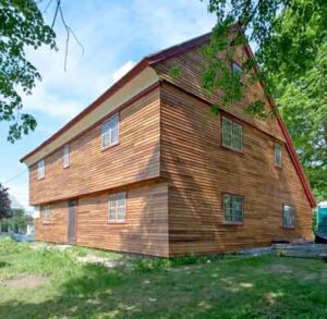
The new permanent settlement on Cape Ann was not laid out in Fishermen’s Field but a mile and a half away on the marshes at a bend in the Annisquam River, on land presently occupied by Friendly’s Restaurant (which closed in 2018, a Chinese restaurant, Grant Circle, the White-Ellery House, Washington St., and the Rte. 128 extension. The White-Ellery house, an authentically restored colonial structure, was originally built on a nearby lot in 1708 for Gloucester’s first Anglican pastor, Rev. John White (who bore no relation to the Rev. John White who founded the Dorchester Company–also no relation to the John White who painted watercolors of the Indians in Virginia and the Carolinas). The White-Ellery house was moved from its original site for the construction of Rte. 128.
White-Ellery House Restoration
 The newcomers to Cape Ann were not so concerned with anchorages and fish landings, nor with large scale farming, nor with fulling mills or the establishment of a textile industry. They sought fertile soil for small, self-sufficient, family farms and pasturage for their cattle. They looked inland along the riverways and uplands. The commons on which they grazed their cattle included Wheeler’s Point, parts of Dogtown, parts of Eastern Point, Emerson Ave., and along Washington Street and Cherry Street around Mill Pond. Meetinghouse Green–opposite the White-Ellery House and near the first houses of worship and the first schoolhouse– was the training ground for the militia.
Map of Gloaster/Glosta Plantation
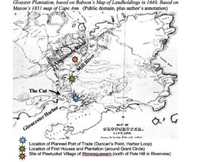
For the future fishery industry and port of trade, the proprietors also laid out lots on the Harbor at the site later known as Duncan’s Point, now Harbor Loop, and along Pavilion Beach for agents of the wealthy Puritan merchant-banker they hoped to bring in to make the Cut and finance and regulate shipping on the canal. Their intended merchant prince was Maurice Thomson (Tomson, Thompson), a powerful international trader from London with many associates and the active sponsorship of Robert Rich, the 2nd Earl of Warwick, who had helped procure the charter for the Massachusetts Bay Colony in 1628 and was president of the New England Company until 1631. Rich also sponsored colonies in Connecticut and Rhode Island and several other trading companies. Thomson was involved in trade from Canada (furs) to Virginia (tobacco) and from the West Indies (sugar) to the East Indies (camphorwood). He had extensive landholdings in all these places and shipped tobacco from Virginia to London as early as 1617. He was also a privateer against Spanish treasure ships and an interloper in the slave trade [21].
In 1639 the General Court passed an “act for the encouragement of Mr. Maurice Thompson, merchant, and others, who intend to promote the fishing-trade,” in which it was “ordered that a fishing-plantation should be begun at Cape Ann, and that the said Mr. Thompson should have places assigned for the building of houses, and stages, and other necessaries for that use; and shall have sufficient lands allowed for their occasions, both for their fishing and for keeping of cattle, and corn, etc.; and that such other fishermen as will join in the way of fishing, and inhabit there, shall have such lands and other liberties there as shall be needful and fit for their occasions.” The General Court also enacted certain privileges, such as exempting fishermen from compulsory military service and taxes on their catches (although they still were prohibited from fishing on Sundays) [22].
The General Court formally invited Thomson to Gloucester in 1641, offering inducements of more landholdings and complete control over the canal and port. A house and stage were built for him in anticipation of his arrival, and kept available to him over the next ten years, but there is no evidence that he ever came or had any desire to participate in the making of Gloucester. At the time, the merchant-banker was searching for silver mines on the coasts of Nicaragua and Panama. According to Thomas Lechford, in 1641 Thomson’s house was being occupied by William Southmead (Southmayd), who had received it from John Endicott, at that time Lieutenant Governor of the Mass. Bay Colony. The town records for 1650 note that “Will Southmaead (Southmayd, Southmead) hath given him that psell [parcel] of land in the harbour upon which Mr. Tomson’s frame stood ; provided yt [that] if Mr. Tomson or his agent shall demand it, that then upon compensation for the charges about it, this said grant is to be surrendered up” [23].
Map showing Thomson/Southmayd Parcels
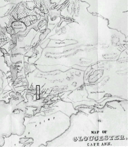 Maurice Thomson’s trading partners and agents in Massachusetts Bay Colony during the 1630s and 40s were Joshua Foote (a London ironmonger who emigrated to Braintree) and Nicholas Trerice, a “conveyancer” and master of the ship, The Planter. These men in turn were trading partners with well-known merchants in colonial New England, such as John Manning (fish) and Abraham Shurt (furs). The merchant families formed a tight-knit cadre of competitors who associated with each other, and even intermarried, for mutual gain. They were immensely powerful because of their access to commodities and because they were independently wealthy in addition to being backed by nobles and royals in England.
How different Gloucester’s history might have been had the times continued to favor nobles and royals. In 1641 the Earl of Warwick and Maurice Thompson did not invest in Gloucester, however, and neither did the Massachusetts Bay Colony. They were preoccupied with the home politics of the times. The English Civil War had commenced, pitting royalists against parliamentarians and ending with the execution of Charles I and the ascendency of Oliver Cromwell, who had no interest whatsoever in colonies. The accompanying economic depression effectively ended the Great Migration and reduced the circumstances of England’s American colonies and of Cape Ann in particular.
The canal project was abandoned until Gloucester on its own found an opportunity in 1642 for a Plan B, following its incorporation as a town. The new town needed a new minister but could not afford to pay one. The selectmen offered a deal: the new minister would get free land and access rights if he would make the Cut and operate a ferry on the canal. Rev. Richard Blynman (Blinman, Blindman) and his retinue from Wales accepted the offer, came up from New Plymouth via Marshfield, and dug the first canal in 1643, connecting Ipswich Bay and Massachusetts Bay, which met at the spot on the Annisquam River known as Dunfudgin’ [24].
The Cut Today
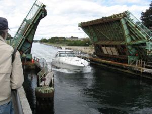 Blynman was not a good fit with Gloucester, however. He repeatedly complained to the General Court about residents’ bad behavior, especially the sacrilegious fishermen, who took the Lord’s name in vain, drank too much, and fished on Sundays—a bit of somewhat proud local lore that has echoed down the years. Court records include several instances of locals being whipped and fined for blaspheming this minister on account of his approbations and unpopular interpretations of the Gospel. In 1644, for example, John Stone was fined 50 shillings for “scandalizing Mr. Blinman for false interpretations of scripture”, and Alee Georg was whipped and fined for calling Blynman “a wicked wretch”.
Blynman and his party, including the first town clerk, Obadiah Bruen, promptly left for New London (formerly Pequot Village) in the Connecticut Colony where, they were assured, the people were godlier. They took the records of Gloucester’s beginnings with them, which were lost but for Bruen’s Town Book, reconstructed after the fact and returned, incomplete, to Gloucester in 1650 [25]. Bruen sent it from the New Jersey Colony where he had ultimately chosen to settle.
Among the settlers on the oldest maps of Cape Ann, such as the Southmayd map and John Mason’s 1831 rendering, were people with the surnames of Bray, Coleman, Goss, Poole, Riggs, Rowe, Haskell, Gott, Day, Hodgkins, Norton, Appleton, Parsons, Elwell, Thurston, Tarr, Smith, Prince, Kettle, Collins, and many more. Babson lists 169 settlers living in Gloucester before 1700, with roughly a third remaining long enough to leave descendants on Cape Ann. Babson leaves some people out, however. One can only speculate about his motives or criteria (or simple oversight) for excluding certain families from his list. Early Gloucester surnames are [26]:
Addes, Allen, Andrews, Ash, Ashby, Ashley, Avery, Babson, Bailey, Baker, Barge, Bartholemew, Beeford, Bennett, Biles, Blake, Blynman, Bourne, Bray, Briars, Broadway, Brown, Bruen, Butman, Calkin, Card [Chard], Chase, Churchill, Clark, Coe, Coffin, Cogswell, Coit, Collins, Colman, Cook, Coldam, Cornish, Cotton, Curney, Curtis, Davis, Day, Denning, Dike, Dolliver, Dudbridge, Dudy, Duncan, Durgee, Dutch, Ellery, Evans, Elwell, Emerson, Emons, Eveleth, Felch, Fitch, Fogg, Foster, Fryer, Gallope, Gardner, Giddings, Glover, Gooding, Hadley, Hadlock, Hammons, Hardin, Harraden, Harvey, Haskell, Hill, Hodgkins, Holgrave, Hough, Haieward [Hayward], Hughes, Ingersoll, Jackson, James, Jones, Joslin, Judkin, Kenie, Kent, Kettle, Lane, Liston, Lister, Lovekin, Low, Luther, Marshall, Martin, Meades, Merritt, Millet, Milward, Norton, Norwood, Page, Parker, Parkman, Parsons, Pearse, Penny, Perkins, Pool, Powell, Prince, Pritchard, Pulcifer, Rider, Riggs, Ring, Roberts, Robinson, Rouse, Rowe, Sadler, Sargent, Sawyer, Sayward, Skamp, Skellin, Smith, Somes, Southmeade, Stainwood, Stevens, Stover, Streeter, Studley, Symonds, Travis, Tucker, Tybbot, Varney, Very, Vinson, Wakley, Walker, Wallis, Webber, Wellman, Wharf, Whittridge, Window, Witham, Woodbury, Yondall, and York.
Surnames of some other early settlers in Annisquam include Adams, Bradstreet, Burnham, Gott, Griffin, Thurston, and Wheeler.
Annisquam, called Planter’s Neck, is said to have been settled by fishermen sometime in 1630 by a party from Plymouth led by Abraham Robinson. It’s claimed he emigrated from Leyden, but there is no evidence for this and also no evidence that he was the son of the famous Pilgrim pastor, Rev. John Robinson, as claimed. The minister’s sons John and Isaac Robinson appear in vital statistics and on ships’ manifests, but not Abraham. Thornton speculates that Abraham was the unrecorded first-born son of the Rev. John Robinson, because the next-named son follows a biblical progression to Isaac, who emigrated to New England in 1635 at age 15 with his mother and four siblings. The Rev. John Robinson is said to have had eight children, with the names of only six of them known, leaving the possibility that the Annisquam Abraham had this parentage. Many Pilgrim vital records are known to have been destroyed during the English Civil War. The hubris of naysayers matches that of Robinson descendants and illustrates the treacherousness of reconstructing historical genealogies [27].
Planter’s Neck Sign
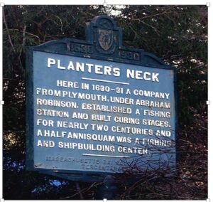 Passenger lists for all the Pilgrim ships to New England through 1638 list many Robinson crossings, but none of them are Abraham. His record may have been lost or he may have been the unrecorded son of another immigrant, such as John Robinson the London customs inspector who came to Virginia in 1607 on the Jamestown. The dates would be right for a son of this John to be exploring Cape Ann in the 1620s. Until around 1630 “Virginia” technically included New England. It would not be surprising for Virginia Colony people to be here, as from the beginning it was common for small vessels to ply the coast, carrying people here and there among the settlements. Abraham could also have been the son of one of the many Robinsons who came as indentured servants to Virginia, St. Christopher’s, Bermuda, and Barbados, who left for New England after their seven years’ service. Free laborers and indentured servants were free to relocate, change their identities, and shed their pasts.
Of course, it’s also possible that the dates for Abraham and/or the founding of Annisquam are off, as Savage and Babson both claim, on different grounds, bringing the date of the Annisquam colony to some time after 1640. Babson unaccountably declares that Annisquam was not permanently settled before 1656 by families with the surnames Robinson, Bradstreet, Harden (Harraden), Bennett, Davis, Lane, Thurston, Gott, Wheeler, and Collins. It’s also been suggested that Abraham may have been an independent fisherman who had joined and then left another Plymouth fishing colony (perhaps Levett’s at Pannaway or Allerton’s at Cushnoc) rather than coming as an immigrant.
In any case, Robinson descendants (there is actually a Robinson Genealogical Society) claim that in 1626 Abraham, son of the minister John Robinson, led a party from Plymouth on explorations along the Cape Ann coast to find a good site for a fishing station, and in 1630 decided on Agassquam (Annisquam as a melding of Agawam and Wonasquam). He and other families (Robinsons married Harradens, Ingersolls, and Days, for example) established a permanent settlement there at Lobster Cove dating to that time.
Whatever his parentage, Abraham Robinson died and was buried in Gloucester in 1645. A son Abraham was born in Gloucester in 1642 and married Mary Harraden, lived a long life in Annisquam, and died in 1740. They had sons Andrew (1675) and Abraham (1677) and a grandson also named Abraham (1704). Abraham is curiously apt as a name. The biblical Abraham was commanded to leave his father’s house and travel far into unknown lands. In exchange for his courage (and for observing the practices of monotheism and circumcision), it was promised he would become the father of multitudes in a brave new world.
From the beginning, settlers’ accounts describe friendly relations with the Indians that extended beyond good trading partnerships. At Bass River, Conant’s party and the Old Planters would certainly have had direct contact with the Pawtucket during most of a year. Naumkeag was more heavily populated than Cape Ann for most of the year, with extensive Indian cornfields on the Bass, Danvers, and North rivers and watchtowers and fortifications against the Tarrantines all around the Beverly and Salem Harbors, described by Edward Winslow. Thomas Prince, writing in the 1690s, describes the impressively large Pawtucket settlement of Mathabequa, or Northfield, at the head of the North River in Naumkeag. Archaeological evidence also places Pawtucket settlements at Butt Point, Ramhorn Cove, Winter Island, Cat Cove, and Salem Willows, as well as sites in Agawam and Wenesquawam [28].
Even if the Pawtucket had suspended farming in Agawam, Wenesquawam, and Naumkeag (after the first 50 or so years of English occupation), they would still have returned seasonally to fish, dig clams, and trade. It was not until the 1680s and 1690s, after King Philip’s War of 1675-1676, that colonists came to regard all Indians as enemies, Gloucester disarmed its local Pawtucket, and some fishermen and sea captains took up sanctioned bounty hunting at £10 to £100 per Indian scalp.
According to an affidavit made in 1680 by Humphrey Woodbury, son of John Woodbury, a passenger on the 1624 voyage of the Zouch Phenix to Fisherman’s Field [29]:
I understood that my…father came to new England by order of a company caled Dorchester company (among whome mr. white of Dorchester in England was an active Instrument) & that my father and the company with him brought cattle & other things to Cape Ann for plantation work & there built an house & kept theire cattell & sett up fishing & afterwards some of them removed to a neck of land since called Salem: After about 3 yeares absence my said father returned to England & made us acquainted with what settlement they had made in new England & that he was sent back by some that Intended to setle a plantation about 3 leagues west of Cape Ann. to further this designe after about half a years stay in England, my father returned to new England & brought me with him: wee arrived at the place now caled Salem in or about the month of June 1628 [in the ship Abigail]: where wee found severall persons that said they were servants to the Dorchester company & had built another house for them at Salem, besides that at Cape Ann. The latter end of that sumer, 1628: John Endecott Esq: came over governor, declaring his power from a company of pattentees, in or about London; & that they had bought the houses boates & servants which belonged to the Dorchester company & that he sd Endecott had power to receive them which accordingly he did take possession of: when wee settled the Indians never then molested us in our improvemts or sitting downe either on Salem or Beverly side of the ferry, but shewed themselves very glad of our company & came & planted by us & oftentimes came to us for shelter saying they were afraid of their enemy Indians up in the country: & wee did shelter them when they fled to us. & wee had theire free leave to build & plant where wee have taken up lands; the same yeare or the next after wee came to Salem wee cutt hay for the cattell wee brought over on that side of the ferry now caled Beverly: & have kept our possession there ever since by cutting hay or thatch or timber & boards & by laying out lotts for tillage : & sometime after building & dwelling heere, where I with others have lived about 40 yeares. [Italics mine]
William Dixy [Dixey], who came in the Higginson Fleet to Beverly, attested in 1680 at age 73 to “amity and friendship” with the Pawtucket in Agawam and Naumkeag:
…I came to New England and arrived in June 1629, at Cape An, where wee found the signes of buildings and plantation work & saw noe English people, soe we sailed to the place now called Salem, where we found Mr. John Endicott, Governor, and sundry inhabitants besides: some of whom said they had beene servants of Dorchester company: & had built at cape an sundry yeares before wee came over, when we came to dwell heare the Indians bid us welcome & shewed themselves very glad that we came to dwell among them and I understood they had kindly entertained the English that came hether before wee came, & the Indians & the English had a field in common fenced in together, & and the Indians fled to shelter themselves, under the English oft times, Saying they were afraid of theire enemy Indians in the contry: In perticular I remember sometime after, I arrived, the Agawam Indians, complained to Mr. Endicott that they weare afraid of other Indians, caled as I take it tarrateens, Hugh Browne was sent with others in a boate to agawam to the Indians releife, & and at other times we gave our neighbour Indians, protection from theire enemy Indians. [Italics mine]
In addition to planting and sheltering with the English, the Pawtucket were the colonists’ best customers for the Indian corn they grew. Higginson describes the planters’ profits in exchanging corn to the Indians for beaver skins worth comparatively more in European markets [30].
The Governor [Endicott] had a garden with lot of green pease growing in it, as good as were ever seen in England. There were also in the plantation plenty of turnips, parsnips, carrots, pumpkins, and cucumbers. The Governor had planted a vineyard with great hope of increase. An abundance of corn was growing. The planters hoped that year to harvest more than a hundred fold….One man said that from the setting of thirteen gallons of corn he had had an increase of fifty-two hogsheads, every hogshead holding seven bushels, London measure, and every bushel had been sold to the Indians for an amount of beaver skins equivalent to eighteen shillings.
Thus, from thirteen gallons of corn, worth six shillings, eight pence, a single farmer made in one year about £327 [roughly a 936 percent profit].
Francis Higginson, Edward Johnson, William Wood, and other observers of the 1630s remark on the friendly relations between the English and the Indians living with or near them in Agawam and Naumkeag. In comments like the following they also inadvertently reveal the main argument used by Puritans and Pilgrims alike to disenfranchise Native Americans of their land for the purpose of taming the wilderness:
The Indians do not object to the coming and planting of the English here, because there is an abundance of ground which the Indians can neither use nor possess.
This was the concept of vacuum domicillium, essentially (“untenanted land”, or, literally, “nobody home”). In English common law, land that was not cultivated or prepared for cultivation (“manured”), not permanently built upon (“improved”), and not fenced for animal husbandry (“enclosed”) was vacant land—not owned by anyone (“wilderness”)—and therefore was free to everyone for the taking [31]. For the Pawtucket and other Native Americans of New England this was a novel concept. Ultimately, for those in a position to attempt to assimilate, even fences failed them. How did this expropriation play out? More, how did land and resource use by Native Americans and English colonists impact the environment and economy then and now?
Notes and References
- See the Sheffield Patent of 1623 at https://www.loc.gov/resource/rbpe.03300100/. Thornton’s discussion of its provisions is on pages 31-37 of his 1854 history, The Landing at Cape Ann: or, The charter of the first permanent colony on the territory of the Massachusetts Company.
- John Babson’s retelling of Bradford’s “useless patent” and “drunken beast” begins on p. 34 of his History of the Town of Gloucester, Cape Ann, Including the Town of Rockport, 1860 (350th Anniversary Edition, 1972). Primary sources include Bradford’s History of Plymouth Plantation, Collection of the Massachusetts Historical Society, Volume 11, Series 4: 1-89 (1856, the unabridged Fulham manuscript with letters). See also Governor William Bradford’s Letter Book. Massachusetts Society of Mayflower Descendants, Boston (1906).
- The New England Company was hedging its bets by giving out more than one charter to ensure a Puritan fishing colony. Thornton’s interpretation making Plymouth and its Pilgrim fishery at Straitsmouth the first fishing venture on Cape Ann is expressed in The Landing at Cape Ann. Other sources pointing to Plymouth precedence include Records of the Great Council of Plymouth, February 18, 1622-1623 (Boston: Commonwealth Museum) and Records of the Colony of New Plymouth in New England, Vol. I Deeds & Etc. 1620 to 1651, in the Book of Indian Records for Their Lands (Massachusetts Historical Commission Archives, 1861). Others, in contrast, do not acknowledge, or even mention, Plymouth’s precedence, such as Herbert Adams’ The Fisher Plantation of Cape Anne, 1882. Part I of The Village Communities of Cape Ann and Salem, Historical Collections of the Essex Institute: 19 (1882). A useful secondary source for the 22 overlapping charters and patents for Massachusetts is Eugene Stratton’s Plymouth Colony, Its History and People 1620-1691 (1973).
- Sources for Ferdinando Gorges’ and John Mason’s claims and their suits in court include Gorges’ Sir Ferdinando Gorges and His Province of Maine: A Briefe Narration… (1658); America Painted to the Life…. (1659); and Letter relating to Maine, Essex Institute Historical Collections 7: 271 (1661). See also John Wingate Thornton, Colonial Schemes of Popham and Gorges. Speech given at the Fort Popham Celebration, August 29, 1862 (Maine Historical Society1863).
- Babson’s retelling of this event begins on p. 19 of his History of the Town of Gloucester.
- Bradford’s complaint of having been dispossessed of Cape Ann by adventurers is in several letters and his commonplace book. His account of the confrontation in Fisherman’s Field is in his entries for 1626 in his History of Plimoth Plantation. The presence of Plymouth fishing camps on Cape Ann are mentioned in Records of the Great Council of Plymouth (February 18, 1622-1623).
- Information on Allerton and Winslow at Cushnoc appears in William Baker’s 1973 Maritime history of Bath, Maine and the Kennebec River region (Marine Research Society of Bath); Charles Pope’s 1908 Pioneers of Maine and New Hampshire 1623 to 1660; and George Varney’s History of Kennebec County, Maine, in A Gazetteer of the State of Maine (1886).
- Herbert Adams, John Babson, James Pringle, and Roger Babson all repeat an ancient, inaccurate, oversimplified version of this showdown story, also encapsulated in Ann Rowe’s article, The Settlement of Cape Ann (Rockport Review, 1906) and enshrined in a vertical file in the Gloucester Archives and on the plaque in Fisherman’s field. I have not been able to find the original source. See, for example, Town of Gloucester Records, 1642-1760 (Sawyer Free Library, Gloucester: Microfilm box #0876172). The General Court’s decrees of 1630 are in various places, including Nathaniel Shurtleff’s 1853 Records of the Governor and Company of Massachusetts Bay and General Court, Vol. II 1642-1649 (Mass. Archives).
- Summaries of Roger Conant’s decision and what he did not like about Cape Ann are given by William Hubbard in A General history of New England: from the discovery to 1680 (Volume 5 of Collections of the Massachusetts Historical Society, 1815), and by John White in The Planter’s Plea (1630). See also p. 12 in Volume 1 of Alexander Young’s 1846 Chronicles of the First Planters of the Colony of Massachusetts Bay, 1623-1636.
- Roger Conant’s career is discussed in Fred Gannon’s article, Roger Conant and the Fishing Station of 1626, in Some Starts of Industry and Commerce in Old Salem; George Phippen’s Biographical sketch of Roger Conant (Essex Institute Historical Collections: 1: 145); and Frederick Conant’s 1877 History and Genealogy of the Conant Family in England and America (http://www.archive.org/details/historygenealogy00cona). Speculations about successions to power in the early Mass. Bay Colony appear in Joseph Felt’s Biographical sketch of John Endicott; Opinions on Winthrop and Endicott and who was the first governor of Massachusetts (Essex Institute Historical Collections 5:73, 8: 96, and 15: 298). For a roster of leaders, see Officers of the Massachusetts Bay Commonwealth 1630-1686: www.winthropsociety.com/doc_officers.php. The evolution and various renamings of forts in Gloucester and Boston Harbor are described in P. Payette’s 2010 American Forts (http://www.northamericanforts.com/East/ma.html#defiance).
- Samuel Maverick, William Wood, and others witnessed and commented on the remarkable talents of Passaconaway. See especially Daniel Gookin’s report of 1674 in Historical collections of the Indians of New England and their several nations, numbers, customs, manners, religion, and government before the English planted there (Massachusetts Historical Society Collections Paper 13: http://digitalcommons.uri.edu/sc_pubs/13/). Useful secondary sources are Russell Lawson’s Passaconaway’s Realm (University Press of New England, 2002) and Janice Brown’s May 17, 2007, New Hampshire’s First Leader, Sagamore of the Penacook, Diplomat and Peacemaker: Passaconaway (c1580-c1673): http://cowhampshire.blogharbor.com/blog/_archives/2007/5/17/2790870.html#axzz1N1jiGjRP.
- Endicott’s appropriations and redistributions of lands are reported in Records of the Company of the Massachusetts Bay in New England From 1628 to 1641 (Mass. Archives): http://archive.org/details/recordsofcompany00mass. For Endicott’s grant to the Old Planters of Salem Village in response to White’s Planter’s Plea, and the 1635 map, see Robert S. Raymond’s web site (2002): http://www.rootsweb.ancestry.com/~raymondfamily/Beverly1700. See also the records of the Salem Court of Assistants in the Collections of the Massachusetts Historical Society and their Collection of Primary Sources Archive for Essex County History, especially http://www.usingessexhistory.org/primaryresources.shtml and http://teh.salemstate.edu/teh/pscontact_1763.html.
- See General Laws of the Massachusetts Colony Revised and Published by Order of the General Court in October 1632 – Revised edition, November 1675 (http://www.usingessexhistory.org/primarydocuments/institute07/princelaws.pdf), and Bibliographic sketch of the laws of the mass colony from 1630 (William Whitmore, 1890, P-665 Microfilm reel #37, Mass. Archives).
- Sources for land disputes and their resolution following the sweeping reforms of 1630 include, in addition to the General Laws and cases in the records of the Court of Assistants, cited previously, Roy Agaki, The Town Proprietors of the New England Colonies: 27-124 (1963, originally published 1924). Land issues in the establishment of Gloucester are prominent in Gloucester Records [1642-1874]: Assorted town records such as records of deeds (1701-1914) and the Commoner’s book (1707-1820). Examples include “Records of land grants, division bounds, thatch lots, herbage lots and wood lots, and highway”, and “Minutes of meetings of Proprietors of Common Lands”, in the Mass. Archives in Boston (Microfilm A 632). The principal source for Native American deeds and redeeds is the Southern Essex County Registry of Deeds in Salem, MA, with data based largely on Sidney Perley, The Indian Land Titles of Essex County, Massachusetts (1912). See the Registry’s comprehensive web site on Native American Deeds at http://www.nativeamericandeeds.com/.
- Sources for the story of William Jeffreys include Proceedings of the Governor and Company of the Massachusetts Bay, 1629-1686 (CT0-1700x); Early Records of the Kettle family of Salem (1690) in the Essex Institute Historical Collections 2: 256 and 4: 282; Early Records of the Allen family of Manchester in the Essex Institute Historical Collections 24: 223, 302; 25:44, 27: 31; and “William Jeffrey(s)” in RootsWeb. See also Joseph Felt, History of Ipswich, Essex, and Manchester (1966); D. F. Lamson, History of the Town of Manchester, Essex County, Massachusetts 1645-1895; and Gordon Abbott Jr., Jeffrey’s Creek: A Story of People, Places and Events in the Town That Came to Be Known as Manchester-By-The-Sea (2003).
- See, for example, Herbert Adams, Origin of Salem Plantation and Old Depositions relating to Old Planters (Essex Institute Historical Collections 13: 136, 19: 153). For insights on Pilgrim and Puritan restrictiveness, see William Bradford and Edward Winslow, Mourt’s Relation, or Journal of the Plantation at Plymouth (1622); Francis Bremer, The Puritan Experiment: New England Society from Bradford to Edwards (1996); and Bremer and Webster, eds., Puritans and Puritanism in Europe and America: A Comprehensive Encyclopedia (2006).
- See Robert Charles Anderson, The Great Migration Begins: Immigrants to New England, 1620-1633, Vol. 1, and The Winthrop Society’s web site for The Great Migration: Ships to New England 1633 to 1635: http://www.winthropsociety.com/ships.php. For a perspective on the immigrants, see William Richard Cutter’s 1874 compendium, New England families, genealogical and memorial, 1915; The original lists of persons of quality; emigrants; religious exiles; political rebels; serving men sold for a term of years; apprentices; children stolen; maidens pressed; and others who went from Great Britain to the American Plantations, 1600-1700 with their ages and the names of the ships in which they embarked, and other interesting particulars: http://www.archive.org/stream/originallistsofp00hottuoft#page/n5/mode/2up. Woolworkers and weavers of the Great Migration tended to settle more heavily in Ipswich, Rowley, Georgetown, Newbury, and the interior of Essex County than on Cape Ann. See Thomas Gage, History of Rowley, Anciently including Bradford, Boxford and Georgetown for the Year 1639 to the Present Time (1840); Thomas Waters, Ipswich in the Massachusetts Bay Colony, Part I: Records and Dispositions of the Usurpation Period (1905); and John Currier, History of Newbury, Mass. 1635-1902 (1902).
- The Pequot War and its consequences for Cape Ann are described in greater detail in answer to another question. For perspective, see Descendants of Henry Doude, who came from England in 1639 (http://www.dowdgen.com/dowd/document/pequots.html); Lion Gardiner, Relation of the Pequot Warres (1660); and John Mason and Paul Royster, ed., Major Mason’s Brief History of the Pequot War (1736): http://digitalcommons.unl.edu/etas/42.
- Felt, Joseph B., Annals of Salem, from Its First Settlement, Volume I (1827): https://archive.org/details/annalsofsalemfro00jose. The General Court order that “a fishing plantation shallbe begun at Cape Ann” is also recorded in Volume 5 of The Winthrop Papers of John Winthrop Jr. (Mass. Historical Society).
- See the Gloucester Archives: Gloucester MA Town Records, including First Settlement (CC119); Military 1623 (CC87); Town Records Vol. I 1642-1714, including pre-1701 Land Grants (CC59). Thomas Gardner’s career is described in Frank Gardner’s 1907 work, Thomas Gardner, planter (Cape Ann, 1623-1626; Salem, 1626-1674).
- Information on Maurice Thomson and the Earl of Warwick, Robert Rich, their trading partners in New England, and their trading empires comes mainly from Christine Heyrman, Commerce and Culture: The Maritime Communities of Colonial Massachusetts 1690-1750 (1996); Theodore Rabb, Enterprise and Empire: Merchant and Gentry Investment in the Expansion of England, 1575–1630 (1967); and Robert Brenner, Merchants and Revolution: Commercial Change, Political Conflict, and London’s Overseas Traders, 1550-1653 (2003).
- The Massachusetts General Court’s 1639 Act for the Encouragement of Maurice Thompson is in The Deputy (October 1641): 85; also in Duane Hamilton Hurd, ed., History of Essex County (1888). Other acts for the encouragement of fishermen appear in the Massachusetts General Court’s Charters and general laws of the colony and province of Massachusetts (1814).
- Thomas Lechford’s observations of developments in Gloaster Plantation are in Plain Dealing: Or News from New England (1642): http://catalog.hathitrust.org/Record/006686958. See Southmayd’s Map of Gloucester 1642/1643 (given by Governor John Endicott) at http://www.100megspop2.com/jdsouthmayd/willsouthmeadelotgloucesterma.jpg. A record of Southmayd’s sale of the parcel being held for Maurice Thomson (should he grace the town with his presence) is in the Gloucester Town Record for 1650.
- See W. Felch, The Blynman Party, in New England Historical Genealogical Register 53 (1899): 234-241.
- The court cases involving citizens’ blaspheming Blynman are in Volume 1 of Records and Files of the Quarterly Courts of Essex County, Massachusetts, edited by George Francis Dow (1911-1921). A transcription of Obadiah Bruen’s 1650 Town Book is in the Gloucester Archives. For a perspective on the difficulty of relying on primary source documents such as the Town Book, see Dan Beaver’s 2011 article, Politics in the Archives: Records, Property, and Plantation Politics in Massachusetts Bay 1642-1650, in Journal of Early American History 1 (1): 3 -25. Beaver notes (p. 25), “As a text that artfully conceals the art of politics, Bruen’s book attests to the significance of narratives about “order” in new settlements and, when pressed, also offers a glimpse of the politics behind the documentary record historians routinely encounter in the archives.” Particularly relevant for this history of Cape Ann is that the Town Book and other early documents make no reference to the Indians, their villages, or their land, causing some to assume, erroneously, that no Indians were here at the time of settlement.
- See the Babson, History of the Town of Gloucester, Cape Ann: Including the Town of Rockport (1860), also his Notes and additions to the history of Gloucester…(1891): https://archive.org/details/notesadditionsto00babs.
- See The Robinsons and Their Kinfolk by the Robinson Genealogical Society at https://archive.org/stream/robinsonstheirki17robi/robinsonstheirki17robi_djvu.txt. Early Records of the Robinson family of Salem are in the Essex Institute Historical Collection 3: 96-97, as well as Early Records of the Day family (2: 43). John Thornton speculates about Abraham Robinson in The Landing at Cape Ann (1854). See also Abraham Robinson of Planter’s Neck in Vol. 2 of William Cutter’s Historic homes and places and genealogical and personal memoirs relating to the families of Boston and eastern Massachusetts (1908); James Savage’s classic Genealogical Dictionary of the First Planters, in The New England Historical and Genealogical Register (1873) 27 (2); and Henry Waters’ The New England Historical and Genealogical Register (1882) 36: 45; 51. Other sources I used to try to track Robinsons included Frank Holmes’ Directory of Ancestral Heads of New England Families, 1620-1700 (1964); H. F. Andrews’ List of Freemen, Massachusetts Bay Colony 1630-1691, with the Freeman’s Oath (1906): https://archive.org/details/listoffreemenmas00andr; and The Winthrop Society’s web site on Ships to New England 1633 to 1635: http://www.winthropsociety.com/ships.php. See also other web sites with facsimiles of ship passenger lists, such as Sharry Ann Stevens’ Pilgrim Ship Lists, Early 1600s: http://www.packrat-pro.com/ships/shiplist.htm. The idea that Abraham Robinson may not have been an immigrant but a fisherman relocating from another fishing station in New Hampshire or Maine was proposed by Jeff Crawford in a personal communication in August 2012. For information on indentured servitude and examples of contracts of indenture, see the Southern Connecticut University Database on Indentured Servitude at http://libguides.southernct.edu/content.php?pid=173886&sid=1465931 and the Virtual Jamestown Indentured Servants Database at http://www.virtualjamestown.org/indentures/search_indentures.html.
- See Thomas Prince, A Chronological History of New England, in the Form of Annals (1736), which ends with the year 1630, and Edward Winslow, Good Newes from New England: A true relation of things very remarkable at the Plantation of Plimoth in New England (1624). Native forts were among the things Winslow found remarkable. See also Joseph Felt’s Historical sketch of [Indian] forts on Salem Neck, Essex Institute Historical Collections 5: 255.
- Woodbury’s and Dixey’s 1680 depositions are reproduced in Hubbard (he collected them) and in Herbert Adams, Origin of Salem Plantation and Old Depositions relating to Old Planters, Essex Institute Historical Collections 13: 136; 19: 153. See also Humphrey Woodbury’s Deposition on his father John Woodbury’s arrival in Salem in 1624 at http://dougsinclairsarchives.com/woodbury/johnwoodbury1.htm#vitals. Good relations among Pawtucket and colonists at Naumkeag is also attested by Edward Johnson in Wonder-Working Providence of Sions Saviour in New England (1654) and Good News from New England (1658) and by William Wood in New England’s Prospect: A True, Lively, and Experimental Description of That Part of America, commonly called New England (1634): http://www.comity.org/Wood_NE_Prospect.htm. Other than Naumkeag, the town of Stockbridge also saw excellent relations between the Indians and the colonists. Stockbridge Indians owned land in common with settlers, shared town offices, voted in town meetings, and attended the same church.
- See Francis Higginson, New England’s Plantation: A Short and True Description of the Commodities and Discommodities of that Country. London (1630): http://www.winthropsociety.com/doc_higgin.php and his General consideracons for ye plantacon in New England, with an aunswere to seuerall objections. Higginson’s quote about the over abundance of land comes from the latter.
- For a perspective on the concept of vacuum domicilium, see David Allen, Vacuum Domicilium: The Social and Cultural Landscape of Seventeenth Century New England (2014) at http://memorialhall.mass.edu/classroom/curriculum_12th/unit1/lesson2/allen.html.
